
With the typhoon “Libra†forced into Taiwan, “Bulawan†is approaching the eastern coast of China, and the double typhoon effect is gradually emerging.
This year's No. 14 strong typhoon "Libra" was formed on the east side of the Philippines at 08:00 on August 19; the No. 15 typhoon "Bulawan" was followed by the 14th on the 20th on the Pacific Northwest. At 05 o'clock on the 24th, the center of the No. 14 strong typhoon "Libra" on the 24th of August 24th was located at the surface of Taiwan's offshore water about 10 kilometers east of the southeastern coastline of Taiwan Province of China, which is 22.2 degrees north latitude and 121.0 degrees east longitude. The maximum wind force is 14 (45 m / s), the central minimum pressure is 945 hPa. At 05:15, “Libra†landed in Peony Township, Pingtung County, Taiwan. At the time of landing, the maximum wind force near the center was 14 (45 m/s), and the lowest pressure in the center was 945 hectopascals. The 15th typhoon "Bulawan" was strengthened into a strong typhoon in the early morning of the 24th. At 0500 on the 24th, its center is located on the northwest Pacific Ocean surface about 1570 kilometers southeast of Xiangshan County, Zhejiang Province, which is 20.4 degrees north latitude and 133.8 east longitude. Degree, the maximum wind force near the center is 14 (42 m / s), the lowest pressure in the center is 955 hPa.
Compared with the sister typhoons "Sura" and "Davi" who were born on the same day before the same day, the tacit understanding between the typhoon "Libra" and "Bulawan" born before and after the foot is more reflected in the growth process. Mutual influence on each other. Qian Chuanhai, director of the China Meteorological Administration's Typhoon and Marine Meteorological Forecasting Center, said that “Libra†and “Bulawan†will be another pair of twin typhoons in the Pacific Northwest this year, during which the double typhoon effect is close to the distance between them. Will become more and more obvious.
The Central Meteorological Observatory expects that “Libra†will move to the south-south direction at a speed of about 10 kilometers per hour. It will enter the northeastern part of the South China Sea on the morning of the 24th, and then turn to the southwest direction, with little change in intensity. "Bulawan" will move northwest at a speed of 15-20 kilometers per hour, and the intensity will continue to strengthen.
Judging from the current forecast, the paths of “Libra†and “Bulawan†will be affected by the obvious double typhoon effect. The so-called double typhoon effect means that when two typhoons are close together, they will be looped around the connected axis and rotate counterclockwise with each other. The rotation is determined by the size of the two typhoons and the intensity of the circulation. The Japanese meteorologist Dr. Fujihara first observed such a phenomenon in a series of vortex experiments in 1923, so the double typhoon effect is also called the Fujiwara effect.
The double typhoon effect will manifest in many different forms due to the different strengths of the two typhoons. When the difference between the two is large, the weaker typhoon may be dominated or even swallowed by the stronger typhoon. When the two typhoons with similar forces approach, the mutual rotation effect of the two will be more obvious. Ideally, when two typhoons of comparable strength are less than 1500 km away from each other, the peripheral wind fields tend to merge into a large vortex that rotates counterclockwise, and the typhoon moving speed on the east side will accelerate and continue to the northwest. Propulsion, the typhoon on the west side slowed down on the original path (westbound or westbound), and may even turn to the southeast, thus forming two forms of typhoon.
The two typhoons "Libra" and "Bulawan" are trying to demonstrate this mutual effect. The double typhoon effect caused the "Libra" to slow down in the west, and the typhoon "Blawan" in the east would step up the northwest and strengthen its intensity. Qian Chuanhai said that when the typhoon latitude on the east side is higher than the typhoon on the west side and the intensity is stronger than the typhoon on the west side, the double typhoon effect will be more significant. 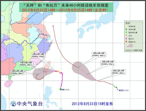
"Liang Li" and "Bulawan" path probability forecast map
The two typhoons caused by the double typhoon effect, such as mutual rotation and merger, greatly increased the difficulty of forecasting the typhoon path. As far as the current two typhoons “Libra†and “Bulawan†are concerned, although “Bulawan†is affected by the subtropical high pressure and the double typhoon effect at the same time, the forecasting difficulty is relatively low due to the slightly stronger peripheral airflow. The future will continue to move northwest.
Due to the influence of the double typhoon effect and the terrain of Taiwan, the "Literin" is likely to maneuver in the northeastern part of the South China Sea, and even turn around to move southeast. Qian Chuanhai pointed out that the uncertainty of the forecast mainly comes from the radius and speed of the "Libra" maneuver.
The sister typhoons "Sura" and "Davi" generated at the end of July were due to the double typhoon effect, which caused the speed of "Sura" to slow westward. However, the rapid "Davi" in the north quickly opened the "Sura". The double typhoon effect was weakened, and eventually “Sura†went ahead independently and landed on the northern coast of Fujian.
The influence of double typhoon on China
Zhang Ling, chief forecaster of the Central Meteorological Observatory, said that although "Bulawan" will enter the East China Sea in the future, it is expected that the impact on the coastal areas will not be too great. After logging in to Taiwan, "Libra" may have a greater impact on Taiwan, Fujian, Guangdong and other places.
Affected by "Libra", from 08:00 to 25:00 on the 24th, the Bashi Channel, the Balingtang Strait, the Taiwan Strait, the southeastern Taiwan Ocean, and the coast of Fujian, the eastern coast of Guangdong, and the coast of Taiwan will have 7-9 winds, some sea areas. Or the winds of the area can reach 10-11, and the gusts can reach 12-13. The winds of the nearby sea surface or area passing through the center of Libra are 12-14, and the gusts can reach 15; Taiwan, Zhejiang East Coast, Fujian Heavy rains have occurred in parts of the southeastern coast and the eastern coast of Guangdong, with heavy rains (250-350 mm) in parts of southeastern Taiwan. Affected by "Bulawan", from 08:00 on the 24th to 08:00 on the 25th, there will be 7-8 winds in the eastern part of the East China Sea, and the gusts can reach 9-10.
color-plated zinc Sleeve Anchor With Hex Bolt,sleeve anchor bolt color-plated,color-plated hex bolt anchor
Hebei Quanfang Fastener Co., Ltd , https://www.quanfangfastener.com